ARIAL DRONE (UAV) - SURVEYS AND 3D MAPPING

|

|
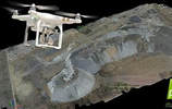
3D MAPPING
|
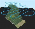
FLIGHT PLAN
|
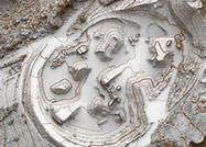
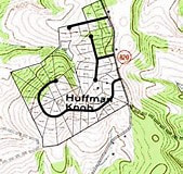
ORTHOPHOTO MAPPING
|
Current Generation drones used for survey 2D topographic maps and 3D terrains surface, are fully autonomous where a flight plan is created and flight images are taken, collected and processed by software for:
- Digital Surface, Terrain and Elevation Models
- 3D point cloud
- Calculate Volumes for earthworks and stockpiles
- Contours overlaid on Orthophoto mapping
- Software: Model Maker, Road Maker, Pix4D and other CAD
- Eliminate the need for high-risk survey walking
- UAV system identifies all surface detail for more information
- Quick turnaround time for larger topographical surveys
LAND SURVEY SERVICES TO RENDER
 GPS SURVEY |
 SURVEY |
CONSTRUCTION
|
LAND SURVEY SERVICES TO RENDER:
- Topographical Surveys / Digital Terrain Models / GPS Surveys
- Construction / Building setting out / Engineering Surveys / Structural As-Built
- Underground Utility Detection / Mapping / Site Surveys / Control / Mapping
- Act as consulting surveyor by checking and verifying all survey activities on site.
This company is equipped with all the modern survey equipment with data recorders. Software packages are compatible with other professions and the most modern technology is used to process and distribute data.
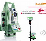
The latest equipment obtained includes Leica GPS and Total Station Flexline.
The latest equipment obtained includes Leica GPS and Total Station Flexline.
